
|
Wahpeton Hotels and Resorts
|

|
|
| | | Hotels & Motels |
| Holiday Inn Express | 1800 Two Ten Dr | Wahpeton, ND | | (701) 642-5000 | | Rodeway Inn | 209 13th St S | Wahpeton, ND | | (701) 642-1115 | | Wahpeton Super 8 Motel | 995 21 Ave North | Wahpeton, ND | | (701) 642-8731 | | Best Inn | 821 Hwy 75 N | Breckenridge, MN | 1.2 mi. | (218) 643-9201 | | Best Western The Falls Inn & Suites | 925 Western Ave | Fergus Falls, MN | 23.6 mi. | (218) 739-2211 | | Days Inn | 610 Western Ave | Fergus Falls, MN | 23.6 mi. | (218) 739-3311 | | Americinn Motel & Suites | 526 Western Ave N | Fergus Falls, MN | 23.7 mi. | (800) 634-3444 | | Super 8 Motel | 2454 College Way | Fergus Falls, MN | 23.7 mi. | (800) 800-8000 | | Comfort Inn | 425 Western Ave N | Fergus Falls, MN | 23.8 mi. | (218) 736-5787 | | Americ Inn Motel | 526 N Cleveland Ave | Fergus Falls, MN | 25.8 mi. | (218) 739-3900 |

|
Wahpeton Weather & Climate
|

|
|
|
The southeast corner of North Dakota endures temperature extremes characteristic of its continental climate. This means long, cold, snowy winters and sunny, hot summers. Spring and autumn are short and highly variable. Meteorological events in southeast North Dakota can include blizzards, hail, rain, snow, polar fronts, tornadoes and high-velocity winds. In general, the state of North Dakota is quite dry, although summers can be quite humid with occasional thunderstorms. The southeastern corner receives the most precipitation in the state, more than 20 inches per year. Springtime flooding is a relatively common event in this region, due to the springtime melt and eventual runoff of rivers in the area.
|
| Month |
High Temp |
Low Temp |
Rainfall |
Ocean Temp |
| January |
17°F |
0°F |
0.62 in. |
- |
| February |
24°F |
7°F |
0.39 in. |
- |
| March |
37°F |
20°F |
1.02 in. |
- |
| April |
56°F |
33°F |
1.76 in. |
- |
| May |
71°F |
46°F |
2.96 in. |
- |
| June |
79°F |
55°F |
3.33 in. |
- |
| July |
84°F |
60°F |
3.53 in. |
- |
| August |
82°F |
57°F |
2.69 in. |
- |
| September |
72°F |
47°F |
2.43 in. |
- |
| October |
57°F |
36°F |
2.03 in. |
- |
| November |
36°F |
20°F |
0.74 in. |
- |
| December |
23°F |
6°F |
0.37 in. |
- |

|
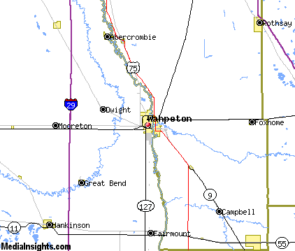
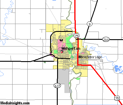
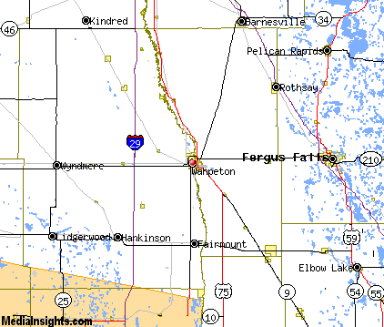
Wahpeton Map & Transportation
|

|
|
 |
|
|
| Click each thumbnail image to enlarge. |
 |
|
 |
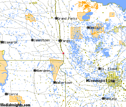 |
The closest airports in the area are the Harry Stern airport (BWP) located about 1 mile south of Wahpeton, Fergus Falls Municipal Einar Mickelson Field (FFM) located approximately 21 miles east of Wahpeton in Fergus Falls, Minnesota, the Hector International airport (FAR) located roughly 46 miles north of Wahpeton in Fargo, North Dakota, Gwinner Roger Melroe Field (GWR) located around 49 miles west of Wahpeton in Gwinner, North Dakota, and finally Chandler Field (AXN) located about 64 miles southeast of Wahpeton in Alexandria, Minnesota.
|

|
Wahpeton Attractions
|

|
|
| | | Golf Courses |
| Bois de Sioux Golf Course | Wahpeton | ND | | | | Pebble Lake Golf Club | Fergus Falls | MN | 25.8 mi. | | | Willow Creek Municipal Golf Course | Barnesville | MN | 28.0 mi. | | | Lidgerwood Golf Club | Lidgerwood | ND | 29.3 mi. | |
| | | Ski Areas |
| Buena Vista Ski Area | Bemidji | MN | 116.6 mi. | |
| | | State Parks |
| Fort Abercrombie State Park | | ND | 12.7 mi. | | | Maplewood State Park | | MN | 36.7 mi. | |
| | | Museums |
| Plains Art Museum | Fargo | ND | 42.8 mi. | (Art) |
| | | Zoos and Aquariums |
| Chahinkapa Zoo | Wahpeton | ND | | | | Bramble Park Zoo | Watertown | SD | 97.8 mi. | |
Notice a problem with the information on this page? Please notify us.
|
Disclaimer: We recommend you conduct your own research regarding all accomodations and attractions found on this website. The distances shown on this website are straight-line distances as the crow flies. The road distance may be considerably longer. You assume all liability for use of any information found on this website. No information is confirmed or warranted in any way. By using our services you agree to the terms and conditions of this disclaimer.
|
| We are the #1 site for your North Dakota Vacation presenting North Dakota vacation rentals, hotels, weather and map for each city. |
North Dakota Vacation .com
©1997-2024 All Rights Reserved.
|